HIGHLIGHTS
- The first ever high resolution airborne geophysics survey on Elizabeth has identified the potential for a much larger scale gold system that significantly increases the footprint and depth extensions of potential gold mineralisation
- The Blue Creek Porphyry intrusion, which hosts the high-grade gold mineralisation at Elizabeth likely covers an area >4x its previously known extent
- The Blue Creek Porphyry appears to extend at least 2km below surface (ie, approximately 10x deeper than currently drill-tested)
- Two additional anomalies have been identified as potential intrusive bodies similar to the Blue Creek Porphyry. These two anomalies show strong continuity along strike and are also extensive at depth
PERTH, AUSTRALIA / ACCESSWIRE / August 2, 2021 / Tempus Resources Ltd (" Tempus " or the " Company ") (ASX:TMR)(TSX.V:TMRR)(OTCQB:TMRFF) is pleased to announce the results of the first ever high resolution airborne magnetic and radiometric geophysical surveys completed over the entire Elizabeth Gold Project in Southern BC, Canada.
The Elizabeth Gold Project is the flagship project for Tempus and is located in the Bralorne - Pioneer Gold District of southern British Columbia. The 115km 2 project is characterised as a relatively underexplored high-grade mesothermal gold system that presents itself in relatively wide (typically ~1-5m wide) vein sets. The high-grade quartz veins encountered in the drilling at Elizabeth show close geological similarities to the Bralorne - Pioneer mesothermal vein system (approximately 30km away), which was mined to a depth of approximately 2,000 metres and produced more than 4 million ounces of gold over a period of 50 years.
Tempus President and CEO, Jason Bahnsen, commented "The results of the geophysical surveys show that the intrusive system that hosts the gold veins at Elizabeth is much larger and extends much deeper than previously thought. There are also two additional large-scale anomalies within the project licence. The results highlight the potential for Elizabeth to complement its high-grade nature with very large scale."
Airborne Geophysical Surveys and Interpretation
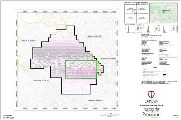
In June 2021, Precision GeoSurveys Inc. was contracted to complete airborne magnetic and radiometric surveys over the Elizabeth Gold Project and completed 97 lines for a total of 735 line-kilometres. Flight lines are oriented east-west with north-south tie lines and spaced 200 metres across the entire 115km 2 Elizabeth property. Over the Elizabeth Main and Elizabeth East Zones a line spacing of 100 metres was flown to increase the resolution and detail over these zones (see Figure 3 below). The airborne magnetic survey data was reviewed and interpreted by Insight Geophysics Inc. using 3D magnetization vector inversion (MVI) modelling.
The geophysical surveys identified the Blue Creek Porphyry, which is the known host of the high-grade Elizabeth gold-quartz veins, as a relative magnetic low anomaly within the Shulaps Ultramafic Complex. From this correlation of geology and geophysics it was determined that the Blue Creek Porphyry, originally explored and mapped to approximately 1.1km 2 in size, is likely much larger. The airborne magnetic survey and MVI 3D modelling interpret the Blue Creek Porphyry to be at least four-times the size at approximately 4.5km 2 (see Figures 1 and 2 below).
This new geophysical data and interpretation of the Blue Creek Porphyry is also extensive at depth, revealing a robust intrusion extending to at least 2km deep (ie, approximately 10x deeper than mineralisation has currently drill-tested). Such an interpretation further indicates the analogous nature of Elizabeth's potential relative to the nearby Bralorne gold deposit (see Figure 2 below).
Historically, the boundaries of the Blue Creek Porphyry have been poorly defined based on mapping of sparse outcrops and therefore not well understood. The airborne surveys, the first of their kind at Elizabeth, are very encouraging as they define a transformationally larger footprint of the main porphyry which gives way to the necessary host geology along strike of the currently known Elizabeth vein/structures as well as unexplored areas to the north, south, and east.
In addition, two other magnetic low anomalies have been identified within the Elizabeth licence area as potential intrusive bodies similar to the Blue Creek Porphyry (see Figure 2 below). These two anomalies show strong continuity along strike and are also extensive at depth.
The Blue Creek Porphyry, which hosts the Elizabeth gold-quartz veins, is thought to have intruded the Shulaps Ultramafic Complex during the late-Cretaceous (70.27 ± 5.25 Ma, by Ar-Ar) and belonging to the late stages of the Coast Plutonic Complex. This timing makes it close in proximity to the timing of Bralorne mineralization (approximately 30km away) and being associated with the same, regional, transpressional environment. Bralorne is a well explored mesothermal vein system, which was mined to a depth of approximately 2,000 metres and produced more than 4 million ounces of gold over a period of 50 years.
The Shulaps Complex is bounded by two major dextral faults, the Yalakom Fault to the north (seen in the airborne magnetics map (see Figure 1) on the Elizabeth property) and the Marshal Creek, Quartz Mountain Faults to the south and west. Within these two regional fault sets are sigmoidal faults, namely the Mission Ridge Fault and the Red Mountain Fault. It is these 2nd order sigmoidal structures that are influential in the Elizabeth vein/fault systems and give them the southwest orientation.
Figure 1 - The Elizabeth Project Geophysics Interpretation
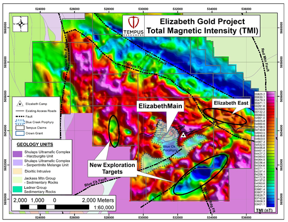
Figure 2 - Elizabeth Project - Geophysics Long Section

Figure 3 - Aeromagnetic survey grid over Elizabeth Gold Property
Elizabeth Drilling Update
Diamond drilling continues at the Elizabeth Main Project with 11 holes, for approximately 2,850 metres, completed to date. Eight holes have had samples submitted to the lab to date. Assays for the first four holes (EZ 21-01 to EZ 21-04) where submitted to SGS Laboratories for assay on 24th June. The first four holes all appear to have intersected strong SW Vein mineralisation. Completion of the initial assays has been subject to delays due to heavy volumes at the lab but are expected to be received in early August.
This announcement has been authorised by the Board of Directors of Tempus Resources Limited.
Competent Persons Statement
Information in this report relating to Exploration Results is based on information reviewed by Mr. Kevin Piepgrass, who is a Member of the Association of Professional Engineers and Geoscientists of the province of BC (APEGBC), which is a recognised Professional Organisation (RPO), and an employee of Tempus Resources. Mr. Piepgrass has sufficient experience which is relevant to the style of mineralisation and type of deposit under consideration and to the activity which he is undertaking to qualify as a Competent Person as defined by the 2012 Edition of the Australasian Code for reporting of Exploration Results, Mineral Resources and Ore Reserves, and as a Qualified Person for the purposes of NI43-101. Mr. Piepgrass consents to the inclusion of the data in the form and context in which it appears.
For further information:
TEMPUS RESOURCES LTD
Melanie Ross - Director/Company Secretary Phone: +61 8 6188 8181
About Tempus Resources Ltd
Tempus Resources Ltd ("Tempus") is a growth orientated gold exploration company listed on ASX ("TMR") and TSX.V ("TMRR") and OTCQB ("TMRFF") stock exchanges. Tempus is actively exploring projects located in Canada and Ecuador. The flagship project for Tempus is the Blackdome-Elizabeth Project, a high grade gold past producing project located in Southern British Columbia. Tempus is currently midway through a drill program at Blackdome-Elizabeth that will form the basis of an updated NI43-101/JORC resource estimate. The second key group of projects for Tempus are the Rio Zarza and Valle del Tigre projects located in south east Ecuador. The Rio Zarza project is located adjacent to Lundin Gold's Fruta del Norte project. The Valle del Tigre project is currently subject to a sampling program to develop anomalies identified through geophysical work.
Forward-Looking Information and Statements
This press release contains certain "forward-looking information" within the meaning of applicable Canadian securities legislation. Such forward-looking information and forward-looking statements are not representative of historical facts or information or current condition, but instead represent only the Company's beliefs regarding future events, plans or objectives, many of which, by their nature, are inherently uncertain and outside of Tempus's control. Generally, such forward-looking information or forward-looking statements can be identified by the use of forward-looking terminology such as "plans", "expects" or "does not expect", "is expected", "budget", "scheduled", "estimates", "forecasts", "intends", "anticipates" or "does not anticipate", or "believes", or variations of such words and phrases or may contain statements that certain actions, events or results "may", "could", "would", "might" or "will be taken", "will continue", "will occur" or "will be achieved". The forward-looking information and forward-looking statements contained herein may include, but are not limited to, the ability of Tempus to successfully achieve business objectives, and expectations for other economic, business, and/or competitive factors. Forward-looking statements and information are subject to various known and unknown risks and uncertainties, many of which are beyond the ability of Tempus to control or predict, that may cause Tempus' actual results, performance or achievements to be materially different from those expressed or implied thereby, and are developed based on assumptions about such Page | 4 risks, uncertainties and other factors set out herein and the other risks and uncertainties disclosed under the heading "Risk and Uncertainties" in the Company's Management's Discussion & Analysis for the quarter and nine months ended March 31, 2021 dated May 14, 2021 filed on SEDAR. Should one or more of these risks, uncertainties or other factors materialize, or should assumptions underlying the forward-looking information or statements prove incorrect, actual results may vary materially from those described herein as intended, planned, anticipated, believed, estimated or expected. Although Tempus believes that the assumptions and factors used in preparing, and the expectations contained in, the forward-looking information and statements are reasonable, undue reliance should not be placed on such information and statements, and no assurance or guarantee can be given that such forward-looking information and statements will prove to be accurate, as actual results and future events could differ materially from those anticipated in such information and statements. The forward-looking information and forward-looking statements contained in this press release are made as of the date of this press release, and Tempus does not undertake to update any forward-looking information and/or forward-looking statements that are contained or referenced herein, except in accordance with applicable securities laws. All subsequent written and oral forward-looking information and statements attributable to Tempus or persons acting on its behalf are expressly qualified in its entirety by this notice. Neither the TSX Venture Exchange nor its Regulation Service Provider (as that term is defined in the policies of the TSX Venture Exchange) accepts responsibility for the adequacy or accuracy of this release.
SOURCE: Tempus Resources Ltd
View source version on accesswire.com:
https://www.accesswire.com/657938/Elizabeth-Geophysical-Survey-Highlights-Scale-Potential