VANCOUVER, BC / ACCESSWIRE / January 26, 2022 / Emgold Mining Corporation (TSXV:EMR)(OTCQB:EGMCF)(FRA:EMLM)(BSE:EMLM) ("Emgold " or the " Company ") announces assay results from three exploration diamond core holes and re-assay results from one historic diamond core hole drilled at its New York Canyon Property, NV (the " Property "). Exploration activities are being carried out by Kennecott Exploration Company (" KEX "), a subsidiary of Rio Tinto plc, in connection with KEX's earn-in obligations under the Earn-In with Option to Joint Venture Agreement (the " Agreement ") between Emgold and KEX first announced by press release on February 11, 2020.
Key exploration results include:
- Hole NYCN0008 intersected 101.89 m of 0.350% CuEq, including 17.14 m of 0.734% CuEq, 4.76 m of 0.783% CuEq, and 3.00 m of 1.062% CuEq as shown in Table 3 below;
- Assay results and favorable rock alteration in hole NYCN0008 expands one of the three main exploration targets on the Property, the Copper Queen Target, to the southeast, where it remains open for further expansion as shown in Figure 2 below; and
- Re-assaying of selected core intervals of historic drill hole MN-27, originally drilled in 1972 and located to approximately 300 m to the west of NYCN0008, reported 30.48 m of 0.300% CuEq, 30.48 m of 0.124% CuEq, and 11.28 m of 0.148% CuEq.
In addition, KEX has selectively re-assayed core from nine historic drill holes drilled in the 1970's and stored on the Property since that time. Results from eight of these holes were summarized in the October 4, 2021, press release. This press release summarizes assay results from historic hole MN-27.
Details on this component of the 2021 exploration program are outlined below.
David Watkinson, President and CEO of Emgold, stated, "KEX has wrapped up its 2021 exploration field work at New York Canyon and we are now awaiting assay results from three diamond drill holes. Results to date are encouraging with hole NYCN0008 showing higher grade CuEq intercepts as well as expanding the Copper Queen Target to the southeast. After obtaining the remaining exploration data from its 2021 exploration program, analyzing the results, and completion of a 3-D exploration model in the first half of 2022, KEX plans to continue its exploration efforts at New York Canyon".
About the New York Canyon Property
The Property currently consists of 417 unpatented claims and twenty-one patented claims totaling approximately 8,700 acres. It is located in the Santa Fe Mining District, Mineral County, west-central Nevada, and about 30 mi. (48 km) east of the town of Hawthorne. KEX is exploring the Property to expand the copper skarn and copper porphyry mineralization. Total historic drilling on the Property, prior to the current drill program, is 234 holes totaling about 43,000 m (139,000 ft).
The Property is an advanced stage exploration project consisting of three main copper targets which were first explored in the mid-1960's, with the last historic drilling done completed in 2006. These historic targets, situated west to east respectively, are called Copper Queen, Champion, and Longshot Ridge. A claim map showing the location of these targets is shown in Figure 1.
The Property is subject to an Earn-In with Option to Joint Venture Agreement (the " Agreement ") between Emgold and KEX first announced by press release on February 11, 2020. KEX can earn up to a 75% interest in the Property by completing up to US$22.5 million in exploration expenditures. Under the terms of the Agreement, KEX has a First Option to acquire a 55% undivided interest in the Property by incurring US$5.0 million in expenditures over a 5-year period (ongoing), of which US$1.0 million is a committed expenditure that must be completed prior to the 18-month anniversary of the Agreement (completed). To date, KEX has spent in excess of US$4.2 million in exploration expenditures on the Property.
Figure 1
New York Canyon Property
Claim Map and Exploration Target Areas
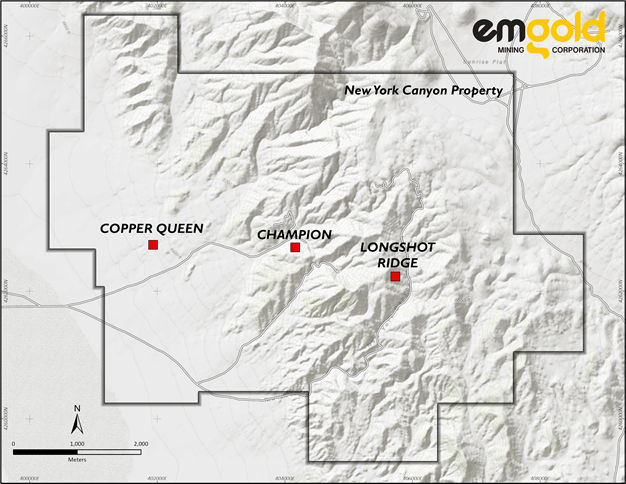
Claim map excludes a block of 27 non-contiguous claims to the north that make up part of the property (the North Block).
Historic Exploration on the Property
From the Copper Queen Target on the west side of the Property to Longshot Ridge Target on the east side, is a length of 6.4 km (4.0 miles). The average width of the known mineralization is 3.2 km (2.0 miles). Copper mineralization, including skarn and porphyry types, is found in all three deposits.
Copper Queen Target
Historic exploration by Conoco in the 1970's and 1980's defined copper sulfide skarn and porphyry mineralization at the Copper Queen Target. Drilling reported in a May 10, 1979, internal report included a significant interval of chalcopyrite and molybdenite mineralization in drill-hole MN-42, drilled in 1977. MN-42 intersected 1,020 ft (310.9m) of 0.41% Cu, 0.012% Mo, 4.5 ppm Ag, and 0.1 ppm Au from 560 ft (170.7 m) to 1,580 ft (481.6 m) (true width unknown). Note this hole was drilled prior to the implementation of NI 43-101 Standards of Disclosure for Mineral Projects and QA/QC procedures are unknown.
KEX re-assayed MN-42, with assay results summarized in the October 4, 2021, press release. The re-assay results included 1,310 ft (399.3 m) of 0.341% Cu, 0.012% Mo, 3.3 ppm Ag, and 0.04 g/t Au (0.443 CuEq) from 350.0 ft (106.7 m to 1,660 ft (506.0 m).
Champion Target
The Champion Target was explored from the late 1960s through the 1970s, but to a lesser extent than Copper Queen and Longshot Ridge. Historic core drilling intersected oxide and sulfide copper skarn mineralization, but historical mineral resources were not delineated.
Longshot Ridge Target
Oxide skarn mineralization has been drilled at the Longshot Ridge Target by various operators since the 1960's. Most recently, Searchlight Resources Inc. (SCLT) (formerly known as Canyon Copper Corporation and Aberdene Mines Limited) drilled the Property between 2004 and 2006 and completed a 2010 Technical Report. Searchlight defined an indicated resource of 16.3 million tons (14.8 million tonnes) of 0.43% Cu and an inferred resource of 2.9 million tons (2.6 million tonnes) of 0.31% Cu solely in the Longshot Ridge copper oxide skarn area. A cut-off grade of 0.20% Cu was used. Emgold's Qualified Person has not audited or verified this resource as a current mineral resource and Emgold is therefore treating this resource as a historical estimate according to NI 43-101 Standards of Disclosure. The 2010 Technical Report can be found under Searchlight's corporate filings at www.sedar.com.
2021 Drilling Program to Date by KEX
Kennecott's drilled ten core holes at the Property in 2021. Assays have been received for seven holes. The status of the current drilling program is shown in Table 1. Seven holes were drilled in the Copper Queen Target. Two holes were drilled in the Longshot Ridge Target. No holes were drilled in the Champion Target. A geophysical anomaly, called Ideal, was targeted with one drill hole and is located to the south of the Copper Queen Target. The location of the ten drill holes drilled to date and ten drill holes re-assayed by KEX (discussed below in this press release) are shown in Figure 2.
Detailed information about the drill holes is shown in Table 2. Results from the drilling are shown in Table 3. NYCN0005 and NYCN0008 showed intercepts greater than or equal to 0.1% CuEq with lengths greater than 10 m. NYCN0006 had intercepts greater or equal to 0.1% CuEq, but lengths were all less than 10 m.
Table 1
New York Canyon Property
2021 Drill Program Status
Hole or Planned Hole | Target | Depth or Planned Depth in Meters | Drilling Status | Logging Status | Samples Sent to Lab | Assays Back from Lab | Assays Tabulated & Analyzed |
| NYCN0001 | Ideal | 347.78 | Complete | Complete | Yes | Yes | Yes |
| NYCN0002 | Copper Queen | 716.28 | Complete | Complete | Yes | Yes | Yes |
| NYCN0003 | Copper Queen | 390.14 | Complete | Complete | Yes | Yes | Yes |
| NYCN0004 | Copper Queen | 348.00 | Complete | Complete | Yes | Yes | Yes |
| NYCN0005 | Copper Queen | 318.52 | Complete | Complete | Yes | Yes | Yes |
| NYCN0006 | Longshot | 503.53 | Complete | Complete | Yes | Yes | Yes |
| NYCN0007 | Longshot | 421.38 | Complete | Complete | Yes | Partial | No |
| NYCN0008 | Copper Queen | 410.56 | Complete | Complete | Yes | Yes | Yes |
| NYCN0009 | Copper Queen | 473.81 | Complete | Complete | Yes | No | No |
| NYCN0010 | Copper Queen | 550.47 | Complete | Complete | Yes | No | No |
Figure 2
New York Canyon Property
Location of KEX 2021 Drill Holes and Re-Assayed Drill Holes
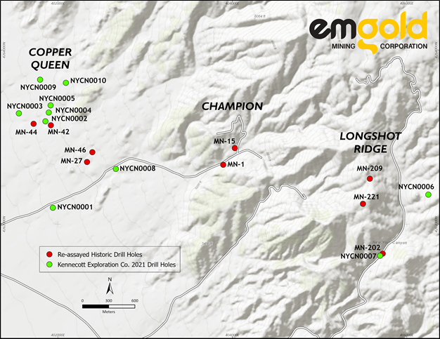
Table 2
New York Canyon Property
Drill Hole Information
Drill Hole Number | Easting | Northing | Elevation (m) | Azimuth (degrees) | Dip (degrees) | Target Depth (m) | Actual Depth (m) |
NYCN0001 | 401942 | 4262189 | 1,421.1 | 142 | -80 | 400 | 347.8 |
NYCN0002 | 401856 | 4263182 | 1,444.8 | 212 | -80 | 700 | 716.3 |
NYCN0003 | 401552 | 4263273 | 1,419.3 | 119 | -80 | 700 | 390.1 |
NYCN0004 | 401894 | 4263282 | 1,449.6 | 360 | 0 | 700 | 348.4 |
NYCN0005 | 401915 | 4263365 | 1,445.0 | 360 | 0 | 700 | 318.5 |
NYCN0006 | 406247 | 4262339 | 1,924.1 | 70 | -85 | 500 | 503.5 |
NYCN0007 | 405693 | 4261637 | 1,901.2 | 340 | -70 | 750 | 421.4 |
NYCN0008 | 402663 | 4262635 | 1,493.9 | 300 | -70 | 400 | 410.6 |
NYCN0009 | 401795 | 4263750 | 1,438.0 | 360 | 0 | 700 | 473.81 |
NYCN0010 | 402091 | 4263624 | 1,480.9 | 360 | 0 | 500 | 550.47 |
Table 3
New York Canyon Property
Drilling Results
Drill Intercepts Greater than 0.1% CuEq
Drill Holes NYCN0005, NYCN0006 to NYCN0008
Hole ID | From | To | Length | Cu | Mo | Ag | Au | CuEq |
(m) | (m) | (m) | % | % | g/t | g/t | % | |
NYCN0005 | 47.70 | 89.93 | 42.23 | 0.205 | 0.002 | 1.756 | 0.011 | 0.228 |
NYCN0006 | 32.00 | 36.22 | 4.22 | 0.164 | 0.000 | 4.861 | 0.010 | 0.213 |
and | 157.50 | 161.50 | 4.00 | 0.053 | 0.000 | 13.994 | 0.022 | 0.191 |
and | 173.50 | 175.00 | 1.50 | 0.007 | 0.001 | 17.400 | 0.012 | 0.181 |
and | 300.96 | 302.50 | 1.54 | 0.022 | 0.041 | 0.137 | 0.001 | 0.159 |
NYCN0008 | 20.00 | 25.00 | 5.00 | 0.144 | 0.006 | 1.905 | 0.007 | 0.181 |
and | 73.15 | 75.10 | 1.95 | 0.105 | 0.000 | 0.537 | 0.004 | 0.111 |
and | 136.55 | 147.24 | 10.69 | 0.312 | 0.003 | 3.641 | 0.025 | 0.358 |
and | 163.90 | 164.89 | 0.99 | 0.129 | 0.000 | 0.417 | 0.004 | 0.134 |
and | 179.60 | 281.49 | 101.89 | 0.178 | 0.046 | 1.916 | 0.009 | 0.350 |
including | 196.00 | 199.00 | 3.00 | 0.004 | 0.317 | 0.122 | 0.003 | 1.062 |
including | 216.86 | 234.00 | 17.14 | 0.360 | 0.101 | 3.604 | 0.024 | 0.734 |
including | 255.00 | 259.76 | 4.76 | 0.538 | 0.054 | 6.587 | 0.032 | 0.783 |
and | 340.46 | 343.69 | 3.23 | 0.067 | 0.013 | 0.611 | 0.002 | 0.117 |
and | 356.10 | 362.98 | 6.88 | 0.232 | 0.016 | 2.260 | 0.006 | 0.308 |
including | 361.78 | 362.98 | 1.20 | 0.972 | 0.010 | 8.730 | 0.014 | 1.089 |
and | 394.58 | 395.59 | 1.01 | 0.228 | 0.006 | 3.210 | 0.006 | 0.279 |
and | 405.00 | 408.00 | 3.00 | 0.086 | 0.013 | 0.784 | 0.003 | 0.135 |
- True widths unknown.
- Copper equivalent grades are calculated based on US$3.00 per lb Cu, US$10.00 per lb Mo, US$19.00 per oz Ag, and US$1,750 per oz Au approximating average prices for those metals over the previous three years. No adjustment has been made for recovery.
Significant assays, defined in this press release as intervals greater than 0.1% CuEq with lengths greater than 10 m are bolded in Table 3. They include:
- 42.23 m of 0.228% CuEq in NYCN0005 from 47.70 m to 89.93 m;
- 10.69 m of 0.358% CuEq in NYCN0008 from 136.55 m to 147.24 m; and
- 101.89 m of 0.350% CuEq in NYC0008 from 179.60 m to 281.49 m including 17.14 m of 0.743% CuEq from 216.86 m to 234.00 m.
2021 Re-Assay Program by KEX
Historic drill core from past drilling programs is stored on the Property. KEX re-assayed selected holes and in some cases selected core intervals of the historic drill core in a specific drill hole. Table 4 shows details of the historic drill holes that were re-assayed by KEX. MN-27, MN-42, MN-44, and MN-46 are in the Copper Queen Target, MN-1 and MN-15 are in the Champion Target, and MN-202, MN-209, and MN-221 are in the Longshot Ridge Target.
Table 4
New York Canyon Property
Re-Assay Drill Hole Information
Drill Hole | Easting | Northing | Elevation | Azimuth | Dip | Total Depth | Date Drilled |
Number | (m) | (degrees) | (degrees) | (m) | |||
MN-1 | 402200.7 | 4262251.0 | 1,606.5 | 360 | -90 | 79.9 | 1972 |
MN-15 | 402469.7 | 4264236.8 | 1,634.3 | 360 | -90 | 732.1 | 1972 |
MN-27 | 398967.1 | 4262313.1 | 1,470.4 | 360 | -90 | 717.5 | 1972 |
MN-42 | 398095.8 | 4266557.6 | 1,484.4 | 360 | -90 | 600.6 | 1977 |
MN-44 | 397684.4 | 4266680.7 | 1,435.0 | 360 | -90 | 609.9 | 1979 |
MN-46 | 399090.8 | 4263465.6 | 1,481.0 | 360 | -90 | 200.6 | 1980 |
MN-202 | 406021.4 | 4252144.3 | 1,810.5 | 360 | -90 | 274.3 | 1979 |
MN-209 | 405685.4 | 4262326.0 | 1,981.6 | 360 | -90 | 422.1 | 1979 |
MN-221 | 405531.5 | 4262038.0 | 1,976.2 | 360 | -90 | 824.5 | 1979 |
Table 5 shows the status of the re-assay program. Re-assay information has been received from all holes.
Table 5
New York Canyon Property
Re-Assay Program Status
Hole ID | Target | Depth in Meters | Logging Status | Samples Sent to Lab | Assay Back from Lab | Tabulated & Analyzed |
MN-1 | Champion | 79.9 | Not re-logged | Yes | Yes | Yes |
MN-15 | Champion | 732.1 | Complete | Yes | Yes | Yes |
MN-27 | Copper Queen | 717.5 | Not re-logged | Yes | Yes | Yes |
MN-42 | Copper Queen | 600.6 | Complete | Yes | Yes | Yes |
MN-44 | Copper Queen | 609.9 | Not re-logged | Yes | Yes | Yes |
MN-46 | Copper Queen | 200.6 | Not re-logged | Yes | Yes | Yes |
MN-202 | Copper Queen | 274.3 | Complete | Yes | Yes | Yes |
MN-209 | Longshot Ridge | 422.1 | Complete | Yes | Yes | Yes |
MN-221 | Longshot Ridge | 824.5 | Complete | Yes | Yes | Yes |
Results from all re-assayed holes, except MN-27, were summarized in the October 4, 2021, press release. This press release contains results only from MN-27.
Table 6 shows the selected intervals that were re-assayed by KEX in MN-27 and Table 7 shows the assay results for MN-27. The impact of storage on the core over this length of time on assay results is difficult to ascertain.
Table 6
New York Canyon Property
Re-Assay Intervals from Historic Drill Hole MN-27
Hole ID | From | To | Length |
(m) | (m) | (m) | |
| MN-27 | 1.524 | 30 | 28.5 |
and | 39.6 | 152.6 | 112.9 |
and | 168.9 | 173.4 | 4.6 |
and | 191.7 | 203.6 | 11.9 |
and | 206.5 | 239.4 | 32.9 |
and | 242 | 245.1 | 3 |
and | 248.3 | 260.6 | 12.3 |
and | 268.5 | 289.6 | 21 |
and | 304.2 | 384.7 | 80.5 |
and | 387.4 | 396.2 | 8.8 |
and | 399.9 | 454.2 | 54.3 |
and | 459 | 461.8 | 2.7 |
and | 467 | 484.6 | 17.7 |
and | 487.7 | 501.7 | 14 |
and | 510.7 | 522.4 | 11.7 |
and | 525.5 | 528.5 | 3 |
and | 546.5 | 588.3 | 41.8 |
and | 604.7 | 607.5 | 2.7 |
and | 609.6 | 612.3 | 2.7 |
and | 617.5 | 628.8 | 11.3 |
and | 635.2 | 644 | 8.8 |
and | 652.6 | 655 | 2.4 |
and | 658.1 | 667.5 | 9.4 |
and | 670.6 | 676.7 | 6.1 |
and | 679.7 | 684.3 | 4.6 |
and | 713.5 | 717.5 | 4 |
Significant assays, defined in this press release as intervals greater than 0.1% CuEq with lengths greater than 10 m are bolded in Table 7. They include 30.48 m of 0.300% CuEq from 97.54 m to 128.02 m, 30.48 m of 0.124% CuEq from 326.14 m to 356.62 m, and 11.28 m of 0.148% CuEq from 617.52 m to 628.80 m in MN-27.
Table 7
New York Canyon Property
Re-Assay Results
Drill Intercepts Greater than 0.1% CuEq
Drill Hole MN-27
Hole ID | From | To | Length | Cu | Mo | Ag | Au | CuEq |
(m) | (m) | (m) | % | % | g/t | g/t | % | |
| MN-27 | 45.72 | 48.77 | 3.05 | 0.096 | 0.003 | 0.684 | 0.003 | 0.116 |
| and | 97.54 | 128.02 | 30.48 | 0.259 | 0.001 | 2.258 | 0.016 | 0.300 |
| and | 146.30 | 149.35 | 3.05 | 0.099 | 0.007 | 1.190 | 0.019 | 0.149 |
| and | 168.86 | 173.43 | 4.57 | 0.688 | 0.002 | 5.179 | 0.041 | 0.781 |
| and | 198.12 | 201.17 | 3.05 | 0.118 | 0.001 | 1.260 | 0.004 | 0.137 |
| and | 213.36 | 216.41 | 3.05 | 0.071 | 0.012 | 1.680 | 0.003 | 0.130 |
| and | 268.53 | 277.37 | 8.84 | 0.046 | 0.031 | 0.679 | 0.003 | 0.159 |
| and | 326.14 | 356.62 | 30.48 | 0.095 | 0.003 | 1.656 | 0.003 | 0.124 |
| and | 408.43 | 411.48 | 3.05 | 0.103 | 0.001 | 1.400 | 0.003 | 0.121 |
| and | 554.74 | 557.78 | 3.05 | 0.120 | 0.000 | 1.030 | 0.005 | 0.134 |
| and | 617.52 | 628.80 | 11.28 | 0.125 | 0.002 | 1.309 | 0.004 | 0.148 |
| and | 640.69 | 644.04 | 3.35 | 0.127 | 0.000 | 1.540 | 0.003 | 0.146 |
| and | 670.56 | 673.61 | 3.05 | 0.105 | 0.000 | 1.740 | 0.005 | 0.127 |
| and | 682.14 | 684.28 | 2.13 | 0.115 | 0.000 | 1.555 | 0.004 | 0.133 |
- True widths unknown.
- Copper equivalent grades are calculated based on US$3.00 per lb Cu, US$10.00 per lb Mo, US$19.00 per oz Ag, and US$1,750 per oz Au approximating average prices for those metals over the previous three years. No adjustment has been made for recovery.
Other Work Completed by KEX as Part of the 2021 Exploration Program
Other work completed as part of its 2021 Exploration Program includes:
- Geologic, structural, and alteration mapping;
- Surface rock chip sampling;
- A UAV drone magnetic geophysics and DEM survey was completed by MWH Geo-Surveys over the majority of the Property and over the northwest corner of the claims;
- A passive seismic geophysics survey completed by Magee Geophysical Services LLC and IM Seismology; and
- Carbon-oxygen isotope analysis was competed for historic holes MN-202 and MN-221.
KEX Plans for 2022
KEX is currently waiting for assays results from NYCN0007, NYCN0009, and NYCN0010. They just received results from the passive seismic reflection survey and are analyzing them. They plan to complete a 3-D geologic model for the Property using Leapfrog software in early 2022 and plan to subsequently permit additional drilling. The scope and timing of any future drilling remains undefined at this time, pending completion of the above work. Note that work continues to be impacted by Covid-19 and delays in obtaining assay results.
QA/QC Methods
Drilling Program
The drill used was a Boart Longyear LF-160. In holes NYCN0005 and NYCN0006, the core size was PQ from surface to 246 and 234 m depths respectively, and then reduced to HQ size. In hole NYCN0008, the core size was reduced from PQ to HQ at a depth of 60 m.
Drill core was initially taken to a field core logging facility on the Property and scanned with an XRF device and quick-logged by the field geologist. Core samples were then shipped to KEX's core logging facility in Salt Lake City, where they were photographed and logged in detail. Detailed logging includes rock types, alteration, and structures. Core was sawed in half, and samples prepared, labeled, and shipped to ALS Laboratories ("ALS") in Elko Nevada. Core samples averaged 2.35 m in length for holes NYCN0005, NYCN0006, and NYCN0008, and ranged from 0.5 to 10.5 m in length.
ALS is an ISO/IEC 17025:2017 accredited laboratory. ALS prepared the samples and analyzed them using ME-MS61L. If certain elements, including copper, exceeded certain values, additional analyses were done using ME-OG62. Gold was also analyzed using method Au-ICP21. The lab inserted standards and duplicates as part of its internal QA/QC program. ALS is independent from both KEX and Emgold.
KEX follows strict QA/QC measures. As part of the KEX QA/QC program, independently certified control samples (standards, blanks, and duplicate samples) were inserted into the sample stream for each analytical batch. In general, a blank was inserted at the start of each stream and then every 10 th sample was a QA/QC sample, alternating between blanks, standards, and duplicates. Standards were inserted with every submitted batch of samples, and to match the level of mineralization as much as possible. Additional blanks were sometimes included before visibly mineralized intervals. Duplicate samples were systematically included. Drill core duplicates are one-quarter core samples. Finally, KEX evaluates the QA/QC results to determine if they meet specifications to ensure proper QA/QC. All holes passed QA/QC in this report.
Re-assaying Program
Historic core samples from historic drillhole MN-27 were selected from storage on the Property and were shipped to KEX's core logging facility in Salt Lake City, where they were photographed. Half core, remaining from historic drilling, was sawed in half (i.e., quartered), and samples were prepared, labeled, and shipped to ALS Laboratories ("ALS") in Elko Nevada. Sample lengths were typically 3.0 m.
ALS is an ISO/IEC 17025:2017 accredited laboratory. ALS analyzed the samples using the method ME-MS61L. If certain elements, including copper, exceeded certain values, additional analyses were done using ME-OG62. Gold was also analyzed using method Au-ICP21. The lab inserted standards and completed duplicates as part of its internal QA/QC program.
KEX follows very strict QA/QC measures. As part of the KEX QA/QC program, independently certified control samples (standards, blanks, and duplicate samples) were also inserted into the sample stream for each analytical batch. In general, a blank was inserted at the start of each stream and then every 10th sample was a QA/QC sample, alternating between blanks, standards, and duplicates. Standards were inserted to match the level of mineralization as much as possible. Duplicate samples were systematically included. As previously noted, KEX evaluates the QA/QC results to determine if they meet specifications
and to ensure proper QA/QC. All historical holes passed QA/QC in this report.
Qualified Person
Technical aspects of this press release have been reviewed and approved by Robert Pease, P.Geo., CPG., the designated Qualified Person (QP) under National Instrument 43-101.
About Emgold
Emgold is a gold and base metal exploration company focused on Nevada and Quebec. The Company's strategy is to look for quality acquisitions, add value to these assets through exploration, and monetize them through sale, joint ventures, option, royalty, and other transactions to create value for our shareholders (acquisition and divestiture (A&D) business model).
In Nevada, Emgold's Golden Arrow Property, the core asset of the Company, is an advanced stage gold and silver property with a well-defined measured and indicated resource. New York Canyon is a base metal property subject to an Earn-in with Option to Joint Venture Agreement with Kennecott Exploration, a subsidiary of Rio Tinto Plc (RIO). The Mindora Property is a gold, silver, and base metal property located twelve miles from New York Canyon. Buckskin Rawhide East is a gold and silver property leased to Rawhide Mining LLC, operators of the adjacent Rawhide Mine.
In Quebec, the Casa South Property, is an early-stage gold property adjacent to Hecla Mining Corporation's (HL) operating Casa Berardi Mine. The East-West Property is a gold property adjacent to and on strike with Wesdome Gold Mine Ltd.'s (WDO) Kiena Complex and O3 Mining Corporation's (OIII) Malarctic Property (Marban Project). The Trecesson Property is located about 50 km north of the Val d'Or mining camp. Emgold also has a 1% NSR in the Troilus North Property, part of the Troilus Mine Property being explored by Troilus Gold Corporation (TLG).
Note that the location of Emgold's properties adjacent to producing or past producing mines does not guarantee exploration success at Emgold's properties or that mineral resources or reserves will be delineated. For more information on the Company, investors should review the Company's website at www.emgold.com or view the Company's filings available at www.sedar.com.
On behalf of the Board of Directors
David G. Watkinson, P.Eng.
President & CEO
For further information, please contact:
David G. Watkinson, P.Eng.
Tel: 530-271-0679 Ext 101
Email: info@emgold.com
Neither TSX Venture Exchange nor its Regulation Services Provider (as the term is defined in the policies of the TSX Venture Exchange) accepts responsibility for the adequacy or accuracy of this release.
Cautionary Note on Forward-Looking Statements
Certain statements made and information contained herein may constitute "forward looking information" and "forward looking statements" within the meaning of applicable Canadian and United States securities legislation. These statements and information are based on facts currently available to the Company and there is no assurance that actual results will meet management's expectations. Forward-looking statements and information may be identified by such terms as "anticipates", "believes", "targets", "estimates", "plans", "expects", "may", "will", "could" or "would". Forward-looking statements and information contained herein are based on certain factors and assumptions regarding, among other things, the estimation of mineral resources and reserves, the realization of resource and reserve estimates, metal prices, taxation, the estimation, timing and amount of future exploration and development, capital and operating costs, the availability of financing, the receipt of regulatory approvals, environmental risks, title disputes and other matters. While the Company considers its assumptions to be reasonable as of the date hereof, forward-looking statements and information are not guarantees of future performance and readers should not place undue importance on such statements as actual events and results may differ materially from those described herein. The Company does not undertake to update any forward-looking statements or information except as may be required by applicable securities laws. The Company's Canadian public disclosure filings may be accessed via www.sedar.com and readers are urged to review these materials, including any technical reports filed with respect to the Company's mineral properties.
SOURCE: Emgold Mining Corporation
View source version on accesswire.com:
https://www.accesswire.com/685538/Emgold-Provides-Exploration-Update-For-its-New-York-Canyon-Property-NV-Reports-10189-m-of-0350-CuEq-including-1714-m-of-0734-CuEq